Critical Speed: The Shallow-Water Resistance Wall
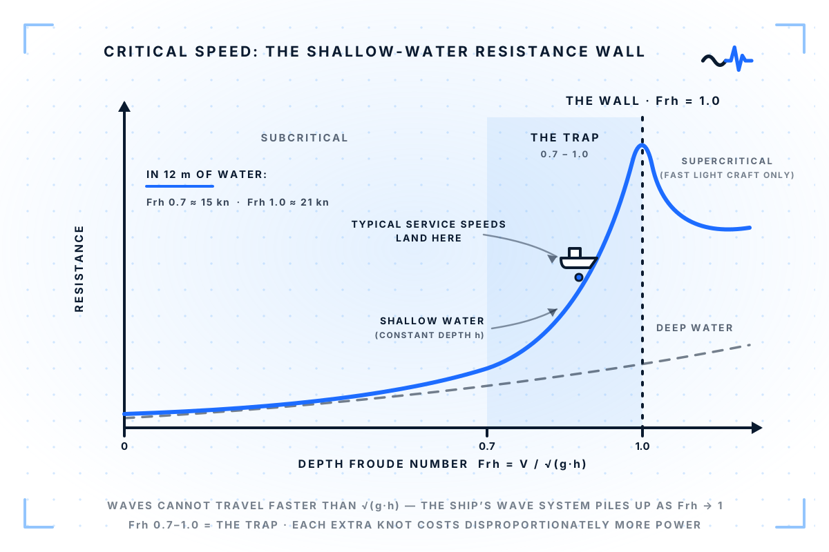
In shallow water waves cannot outrun √(g·h). As the depth Froude number nears 1.0 resistance spikes — and the trap starts at normal service speed.
In 12 metres of water, the sea sets a hard speed limit: about 21 knots. It is not a regulation. It is the fastest a wave can physically travel there. And your ship starts paying for it long before that.
This is the third of the five shallow-water effects this series maps — after squat and the bank effect — and it is the one that turns water depth into a speed decision.
The wave speed ceiling
In shallow water, wave propagation speed is capped at √(g·h) — gravity times depth. A ship's wave system has no choice but to travel with the ship. As vessel speed approaches that cap, something has to give.
The governing parameter is the depth Froude number:
Frh = V / √(g·h)
It defines three regimes:
- Subcritical (Frh below ~0.7) — shallow-water effects are present but manageable. Squat grows, resistance creeps up.
- Transcritical (Frh 0.7–1.0) — the trap. The transverse waves the hull generates can barely outrun the ship. Energy piles into a growing wave system, the wave pattern widens from the familiar 19.5° Kelvin angle toward 90°, and resistance rises sharply and non-linearly. Each additional knot costs disproportionately more power.
- Critical (Frh = 1.0) — the wall. Resistance spikes. A displacement vessel cannot economically push through it; only light, high-powered craft ever operate beyond it.
The trap sits at service speed
In 12 metres of water, √(g·h) ≈ 21 knots — so the transcritical zone begins around 15 knots. In 15 metres, it begins around 16.5. That is not an exotic corner of the operating envelope: it is normal service speed, in depths found across estuaries, straits, and coastal approaches.
The consequences are well documented. In very shallow water (depth-to-draft around 1.2), the same engine power can deliver 15–30% less speed than in deep water. This is also one reason canal authorities impose the speed limits they do.
What the monitoring system sees
Prediction methods exist — Schlichting's method estimates the shallow-water speed loss from the deep-water resistance curve. But most performance monitoring setups do something simpler: they treat shallow-water legs as if they were deep. The result is a power–speed deviation that gets blamed on hull fouling or weather, when it is actually geometry.
The operational lever is speed selection. At Frh = 0.85, slowing down by one knot saves far more fuel than the same knot would in open water — the curve is that steep. A monitoring system that computes the depth Froude number along the route can show exactly where that lever exists, using data the vessel already logs: speed, position, and charted depth.
Does your voyage planning treat water depth as a speed constraint — do you compute the depth Froude number on shallow legs, or discover it afterwards in the fuel figures?